
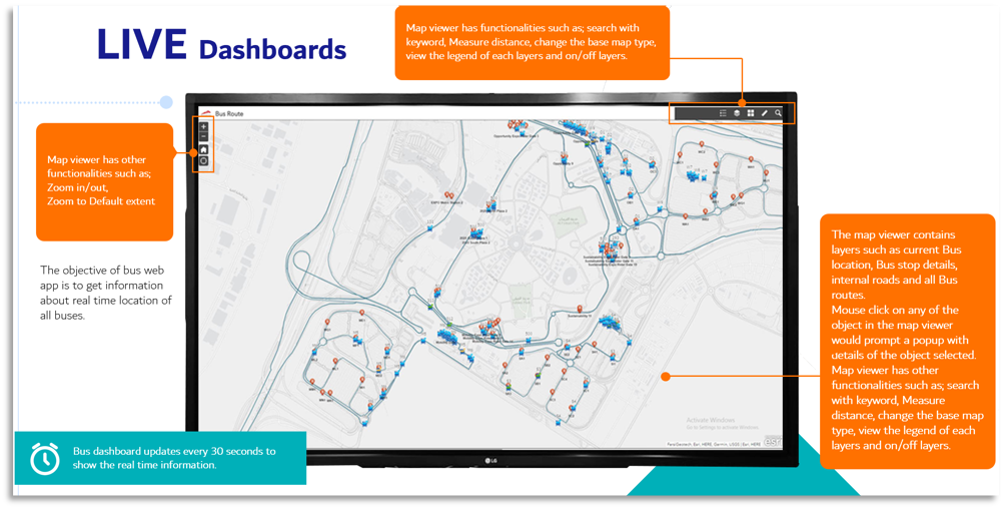
The primary objective of this project was to design and implement a web-based dashboard system to provide real-time tracking and management of mobile assets—in this case, buses operating within a defined geographic area such as a university campus or an enterprise facility. The platform enables stakeholders to monitor current locations, routes, and detailed information about each bus, supporting improved operational efficiency and decision-making.
Technology Solutioning
It involved multiple technology stacks put together for the specific purpose, for example, Leaflet/Mapbox, React (for dynamic UI), PostGIS for spatial data, cloud services, real time updates using websocket and security protocols for encrypted data transfers.
This entire project wasn’t an easy task because of data consistency issues, rendering performances, security and above all GIS Integration Complexities but we had our focus on superior customer experience through simplistic, incremental deliverables.
Solution Approach
MWB combined historical taxi ride data, socia media feeds and weather and event data available by using technologies such as Natural Language Processing (NLP) for sentiment analysis (using libraries like spaCy, TextBlob, BERT), Facebook Prophet for time-series forecasting, Geospatial Analysis to map demand clusters, and ETL pipelines for integrating APIs for social media ingestion.
Project Outcome and Benefits
At the end of the project, we had a success story to bring more operational efficiency through reduced time spent on manual tracking, more analysis around route usage, frequency and delays so that operations can be further optimized and scalability to support additional asset types (e.g. delivery vans, maintenance vehicles).